• Untitled Document

    The 2024-2025 Fund Raising Season has Opened!

    EricsonYachts.org has opened the season for raising funds to support the expenses of the site. If you would like to participate, please see the link below for additional information.

    Thanks so much for your continued support of EricsonYachts.org!

    2024-2025 Fund Raising Info

E35/3 Chart plotters at the helm?

gabosifat

Member III
Hi Everyone,

I'm wondering what other E35/3 owners have done to install a chart plotter at the helm? My son is a long way up the coast of BC, and our current (older) plotter has decided to quit. He's now navigating using paper charts and Navionics on a couple of iPhones. My wife and I will be flying up to take over the boat mid July, and I'd like to take a new plotter up to install when I get there. If anyone has done a recent install of a new chart plotter, can you provide model and perhaps photos of how you did it? Not having the boat hear makes selecting a plotter with the right dimensions, and planning an install somewhat problematic, and communication with my son on the boat is difficult to say the least at the moment.

Many thanks for any replies!
Cheers,
Steve Gabbott
E35/3 Silent Dancer
Gabriola Island B.C.
 

mrojec

Member I
Hi Steve,
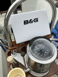
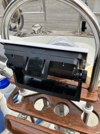
I will be installing a B&G Vulcan 9 chart plotter on an E35/3 in the next few days. I will let you know how it goes. I'll also post pictures. Basically I made a wood base that clamps across the pedestal risers in front of the compass. The plotter bracket and plotter mount on top of the base. It looks like it will fit, but this was done far away from the boat a couple of months ago without exact dimensions. I'm working on the boat daily now and can tell you that, on this boat at least, the steering pedestal risers are 1" SS tubing 12.5" apart O.C.

Mark Rojec
E35/3 Luminosity
Port Henry, NY
 

Bolo

Contributing Partner
How about seeing a video on how to install a chart plotter at the helm? This past winter I install a Raymarine Axiom chart plotter to replace the old Garmin that I had at the helm. It’s not the same as a B&G and a E35 (mine is a E32-3] but you may get some ideas. Click on the link to see the video on my YouTube channel and for the chart plotter part start at the 6:51 time stamp.
 

Pete the Cat

Sustaining Member
I have had this dilemma on both of my boats. I realize my solutions are probably not mainstream.. Much of this depends on how you use the boat. Putting your one chart plotter on the helm seems like a mistake if you are really going to go ooastal or offshore cruising. Almost anything will work if you are just day sailing in known waters. They are improving, but the screens are hard to read in bright sun, the multi function buttons on most of them are confusing and--frankly--when you are offshore or going places you are likely going to have the autopilot or some self steering mechanism engaged--or have crew steering a course-- and you really want to be able to plan ahead when actually doing real navigation planning. Route planning for me does not occur at the helm. Even here in Maine doing familiar passages. I generally prefer to do my serious navigation planning in the company of radar inputs and seeing larger scale charts to set courses and tack planning. I once delivered a yacht from Annapolis to Maine and its sole dinky chartplotter/radar screen was at the helm and it was really problematic. The screen was small and clunky to toggle the multifunction buttons to see miles ahead for planning and the radar definition was inadequate at any scale it showed. Felt like navigating through a peep hole. I swore I would not do this on my boat.
Here is how I do it on my boats;
I have my main chartplotters below decks. For my main chartplotter, I use an Ipad with iNavx software because this give much better touch options and much larger scale. The Ipad can carry every NOAA chart at every level of detail with no problem and updated free from NOAA. If I needed to, I could take the IPad into the cockpit, but rarely do that. I have another old chartplotter running as back up at the nav station, but it is loaded with what are probably outdated charts. I have yet another Raymarine chartplotter (Dragonfly) that I have on a portable mount with plug in power from the binnacle. This is useful for keeping track of close in buoys on shooting the narrow passages here in Maine. But it would be a challenge to use that for all my planning. Toggling it to larger scale (the multifunction buttons are not fun) is really clunky. My view is that it is only useful for navigating tight passages at the helm.
I have also switched to using another Ipad (they are cheap and much more powerful than most chartplotters) for rader with a Furuno wireless radar system. This software provides all the capabilities of radar anywhere i want, at a scale you adjust easily with screen touch. The second Ipad is loaded with INavx software so could be a backup if I had a problem with my main Ipad. I think I paid about $300 apiece for each of them (with GPS).
I am a pilot and Ipads have become basic instruments that most general aviation pilots use for basic navigation and operations. The very expensive FAA approved and required instruments in most general aviation airplanes are still there, but most pilots find the Ipads have much more power and the software is much less clunky, gives far more information, and are less difficult to use while flying. I am not sure why Ipad use has not come over to boaters, but I suspect that lots of boats are outfitted but not really used for longer distance cruising, so perhaps it does not matter.
Just one take on the matter. Your needs may vary.
 

Bolo

Contributing Partner
Like with many other devices, gizmos, gadgets and running rigging what we use and how we use them on our boats depends on where and how we sail, with that I agree. I’m based out of Annapolis and all my sailing is done on the bay, although now that I’m retired and the boat has had some important improvements I’m looking forward to some coastal cruising at least. IMHO, having a chart plotter at the helm when sailing waters like the Chesapeake Bay is almost required. I say almost because if you have local knowledge or an updated chart (paper preferred but electronic will do) then you can get by. My recent upgrade to a Raymarine chart plotter have turned out so far to be a very good improvement. The Axiom with it‘s touch screen is much easier to use then my old Garmin with the multiple buttons and the screen certainly seems bright enough to me but I have a “permanent“ bimini and shaded cockpit because I’m a cancer survivor with two cases of skin cancer under my belt. As for planning routes on the bay, which in some ways are more critical than ocean passages in some ways because there are lots of things you can hit and plenty of shoals, I use paper charts but more recently started using Navionics on my iPad. I think there is even a way to transfer routes from my iPad to my Aniom chart plotter wirelessly but I haven’t tried that yet. If I did more ocean cruising then I’d probably install another chart plotter at the Nav station I’m sure because I’m guessing that planning an ocean passage in the comfort of a warm, dry cabin is preferable to doing it in the cockpit in the rain.
 

Prairie Schooner

Jeff & Donna, E35-3 purchased 7/21
Hi Steve,
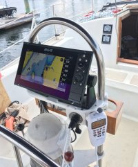
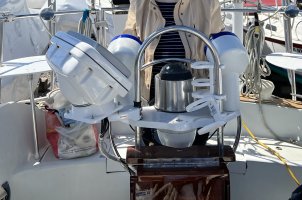
We have a B&G Zeus 9" at the helm of our E35-3. We mounted it on a shelf by A Propos Marine.
- https://www.aproposmarine.com/index.php?route=product/product&product_id=63
I made the Starboard mount additions for the remote mic.

helm plotter mic 1 E35-3 sm.jpg

This is a 'temporary' solution until we get it in a pod. We've looked at some off-the-shelf pods and I'm thinking of fabricating a custom pod. In the meantime, we store the plotter below decks when we're not using the boat. It's getting to be a real pain moving it every time.

We raised the pedestal guard to mount the shelf and get the plotter a little further from the compass*. We did this with SS couplers for 1" tubing and added 8" long SS stubs to the bottom. The cable is in corrugated cable tube from a gland in the deck. Some (most?) pod solutions might (will?) require a higher or angled pedestal guard beyond what is standard on the 35-3.

Ray (Pete the Cat) makes a good point about doing planning at the nav station rather than the helm. The Zeus is supposed to mirror with complete functionality to an iPad. We plan to use a tablet, but at the nav desk because it is less weatherproof, screen visibility, and for charging. So far, we're very pleased with the Zeus.

* Some folks worry about the magnet in the chart card slot affecting the pedestal compass. We haven't had time to really analyze that.

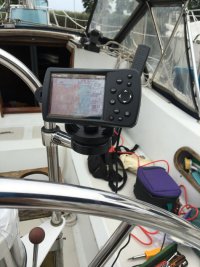
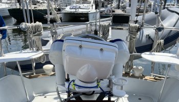
For reference, this is what we inherited with the boat:
mfd helm 40 sm.jpg
The battery was shot so we had to run a 12v extension cord below decks.

Cheers,
Jeff
 
Last edited:

Rosco

Exploring the BC Coast E35-2, Yanmar 3GM30
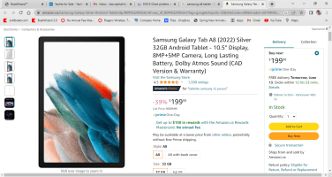
I bought a Samsung A8 with the big screen...10.5 inches on a detachable mount. No Sim card for $200. It utilizes all GPS and GLONASS. Navionics is my only download and it is only used for Navigation. I rarely look at my chartplotter and can detach the tablet, take it inside over dinner and plot course or research anchorages away from helm.
 

Alan Gomes

Sustaining Partner
I bought a Samsung A8 with the big screen...10.5 inches on a detachable mount. No Sim card for $200. It utilizes all GPS and GLONASS. Navionics is my only download and it is only used for Navigation. I rarely look at my chartplotter and can detach the tablet, take it inside over dinner and plot course or research anchorages away from helm.
Which models of the A8 come with the GPS hardware? Is it similar to an iPad where you have to buy a cell-enabled model to get the chipset that supports GPS?

Also, do you have a link to where you got yours for $200? And how much memory does yours have?
 

Rosco

Exploring the BC Coast E35-2, Yanmar 3GM30
Which models of the A8 come with the GPS hardware? Is it similar to an iPad where you have to buy a cell-enabled model to get the chipset that supports GPS?

Also, do you have a link to where you got yours for $200? And how much memory does yours have?
Samsung Galaxy Tab a8 Tablet - 10.5 Inch - 32GB - Grey - SM-X200NZAAXAC . This from my original order. remember NO SIM CARD NEEDED. I am not using it for texts or email or calling. You need enough memory for Navionics which is 150 MBs...When i am at home with it I can use all the usual youtube, music, etc etc. You can unpack it, take it home and sign in to WIFI and download Navionics which is almost free per year subscription and you have a better system than most overpriced chart plotters. Amazon has mine on for $200 CAD.


Attachments

  • 2023-06-12.png
    2023-06-12.png
    508.4 KB · Views: 9

Rosco

Exploring the BC Coast E35-2, Yanmar 3GM30
Which models of the A8 come with the GPS hardware? Is it similar to an iPad where you have to buy a cell-enabled model to get the chipset that supports GPS?

Also, do you have a link to where you got yours for $200? And how much memory does yours have?
The Samsung Tablets (A8) have 5 GPS systems built in. Better than Apple...Specs are below, See "positioning"

LAUNCHAnnounced2021, December 15
StatusAvailable. Released 2022, January 17
BODYDimensions246.8 x 161.9 x 6.9 mm (9.72 x 6.37 x 0.27 in)
Weight508 g (1.12 lb)
SIMNano-SIM
DISPLAYTypeTFT LCD
Size10.5 inches, 319.7 cm2 (~80.0% screen-to-body ratio)
Resolution1200 x 1920 pixels, 16:10 ratio (~216 ppi density)
PLATFORMOSAndroid 11, upgradable to Android 13, One UI 5
ChipsetUnisoc Tiger T618 (12 nm)
CPUOcta-core (2x2.0 GHz Cortex-A75 & 6x2.0 GHz Cortex-A55)
GPUMali G52 MP2
MEMORYCard slotmicroSDXC (dedicated slot)
Internal32GB 2GB RAM, 32GB 3GB RAM, 64GB 4GB RAM, 128GB 3GB RAM, 128GB 4GB RAM
MAIN CAMERASingle8 MP, AF
Video1080p@30fps
SELFIE CAMERASingle5 MP
Video1080p@30fps
SOUNDLoudspeakerYes, with stereo speakers (4 speakers)
3.5mm jackYes
COMMSWLANWi-Fi 802.11 a/b/g/n/ac, dual-band, Wi-Fi Direct
Bluetooth5.0, A2DP, LE
PositioningGPS, GLONASS, BDS, GALILEO, QZSS
NFCNo
RadioNo
USBUSB Type-C 2.0
FEATURESSensorsAccelerometer, gyro, proximity, compass
BATTERYTypeLi-Po 7040 mAh, non-removable
Charging15W wired
 

Nick J

Contributing Partner
Moderator
Blogs Author
Hi Steve,
We have a B&G Zeus 9" at the helm of our E35-3. We mounted it on a shelf by A Propos Marine.
- https://www.aproposmarine.com/index.php?route=product/product&product_id=63
I made the Starboard mount additions for the remote mic.

View attachment 47344

This is a 'temporary' solution until we get it in a pod. We've looked at some off-the-shelf pods and I'm thinking of fabricating a custom pod. In the meantime, we store the plotter below decks when we're not using the boat. It's getting to be a real pain moving it every time.

We raised the pedestal guard to mount the shelf and get the plotter a little further from the compass*. We did this with SS couplers for 1" tubing and added 8" long SS stubs to the bottom. The cable is in corrugated cable tube from a gland in the deck. Some (most?) pod solutions might (will?) require a higher or angled pedestal guard beyond what is standard on the 35-3.

Ray (Pete the Cat) makes a good point about doing planning at the nav station rather than the helm. The Zeus is supposed to mirror with complete functionality to an iPad. We plan to use a tablet, but at the nav desk because it is less weatherproof, screen visibility, and for charging. So far, we're very pleased with the Zeus.

* Some folks worry about the magnet in the chart card slot affecting the pedestal compass. We haven't had time to really analyze that.

For reference, this is what we inherited with the boat:
View attachment 47345
The battery was shot so we had to run a 12v extension cord below decks.

Cheers,
Jeff
Jeff,

I really like the placement of your instruments on the bulkhead. We use the autopilot frequently and I don't have access tot he instruments at the helm while sitting on the cockpit combing or on the bench. It looks like this is a great solution. How do you like the setup? Do you have any detail for the backside?

We have an old Raymarine C80 at the navstation and I use my phone or IPAD Navionics for navigation at the helm. We only use the C80 for radar when it gets foggy and have to have someone at the desk relaying info to the cockpit (yelling). I go back and forth on how I want to reconfigure it, but I'm currently thinking of replacing the C80 with a B&G unit at the nav desk and use WIFI to run a tablet at the helm. I'll probably change my mind for the 100th time tomorrow, but that's the current thought.
 

Christian Williams

E381 - Los Angeles
Senior Moderator
Blogs Author
I have about $600 (six years ago) worth of 7" Garmin chartplotter, and rely on it. I have a separate AIS screen (Vesper watchmate) , because AIS on the Garmin clutters it up. Do consider the depth transducer, which may have to be purchased separately if the included one is for a fishing boat transom.

I think the challenge for remote purchase is the mount. The included stand will work if there's a flat surface. Otherwise some sort of pod is required for binnacle mount.

My Vesper is at the nav station and the GPS at the helm. They could easily both be belowdecks, because as a practical matter there is plenty of time to check position, and it's easier to program or interpret or think through things when not blinded by the sun.
 

ConchyDug

Member III
I've been doing a deep dive into sailboat instruments and plotters recently trying to prep some boats for using Expedition software. If you already have instruments/transducers sending 0183 or 2K you can usually tie that into a wifi or USB gateway(Actisense is the brand) that can be pushed to a laptop running OpenCPN or something similar then use Microsoft Team Viewer to run a tablet at the helm. Total cost would be mayyyybe $500 including the tablet and gateway. B&G is nice but I feel they hide a lot of capability behind peripheral units like the H5000 and sail brain box they market. The current Garmin 943 has the capability to run Polars made from a .txt file with B&G you need a H5000 and the sail brain. Also the screen mirroring is more refined on the Garmin as well as Raymarine, I felt like I was stealing Cable TV mirroring the B&G to my Android tablet 10' away for a race last weekend on a J130, so maybe B&G prefers Apple products I dunno. The B&G app seems like they lock features behind a paywall where as the Garmin Active Captain app only has the updated chart packages to purchase. I do a lot of dinghy, catamaran and keelboat racing so I don't use a mast mounted compass/speedo instead I have a Garmin 5 button watch. It can be paired with Garmin chartplotters as well which is handy, there is another company making software to push 0183 & 2K data via their software to a Garmin watch as well so you're not locked behind Garmin's proprietary signal.
 

Tin Kicker

Sustaining Member
Moderator
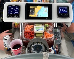
I put the least expensive BnG Vulcan 7" ($499 iirc) at the nav table and control it with n iPad at the helm. Only tricks are to keep the iPad out of the direct heat of the sun and have USB power at the helm.

Nav station while at the dock: (ODay 322)
The VHF puts AIS on the BnG display.
20220608_163750-X2.jpg


Older 11" iPad Pro at Helm:
IMG_2414-XL.jpg

Helm display:
IMG_2418-XL.jpg


I do have a weather case for the iPad but didn't need it on the morning when the photo was taken.

If I just had the BnG at the helm I'd strongly suggest the Zeuss because it has actual buttons and knobs.
 
Last edited:

Prairie Schooner

Jeff & Donna, E35-3 purchased 7/21
Jeff,

I really like the placement of your instruments on the bulkhead. We use the autopilot frequently and I don't have access tot he instruments at the helm while sitting on the cockpit combing or on the bench. It looks like this is a great solution. How do you like the setup? Do you have any detail for the backside?

We have an old Raymarine C80 at the navstation and I use my phone or IPAD Navionics for navigation at the helm. We only use the C80 for radar when it gets foggy and have to have someone at the desk relaying info to the cockpit (yelling). I go back and forth on how I want to reconfigure it, but I'm currently thinking of replacing the C80 with a B&G unit at the nav desk and use WIFI to run a tablet at the helm. I'll probably change my mind for the 100th time tomorrow, but that's the current thought.

Hi Nick,
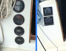
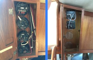
I like this setup a lot. It replicates the arrangement of friends who I have raced with for many years. It's kind of like having a heads-up-display. It also helps crew be more engaged with what's going on. A mast mount would be too far away for my particular eyesight. Our boat came with a dedicated cabinet for the back of the dial instruments which I assume were original. These are before and after photos:

bulkhead inst replace outside sm.jpg . . bulkhead inst replace inside sm.jpg

We have an early Furuno radar with a monochrome screen. It's like being in an old 50's Navy movie. We're told it's too old to connect to the B&G. We keep it almost more as a novelty. To use it seriously we'd need one person below at the nav station and then there's no chart overlay to really interpret what's going on.
Cheers,
Jeff
 

Nick J

Contributing Partner
Moderator
Blogs Author
Hi Nick,
I like this setup a lot. It replicates the arrangement of friends who I have raced with for many years. It's kind of like having a heads-up-display. It also helps crew be more engaged with what's going on. A mast mount would be too far away for my particular eyesight. Our boat came with a dedicated cabinet for the back of the dial instruments which I assume were original. These are before and after photos:

View attachment 47378 . . View attachment 47380

We have an early Furuno radar with a monochrome screen. It's like being in an old 50's Navy movie. We're told it's too old to connect to the B&G. We keep it almost more as a novelty. To use it seriously we'd need one person below at the nav station and then there's no chart overlay to really interpret what's going on.
Cheers,
Jeff
Crew engagement is one of the main reasons I was thinking of going this route. Good to hear it's working well for you.
 

RCsailfast

E35-3 Illinois
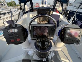
IMG_3813.jpeg
Have a nav pod with a Ray 70 multi display, Ray Axiom7 and Ray autohelm on the binacle. Our Ray E7 chart plotters failed and went with the Axioms as it was the easiest to install in the existing pod. It was also the easiest to connect to the existing electronics and sensors. When the E7 chartplotters chip readers failed we used IPads with Navionics and or charts and an old Garmin 86 hand held. I wish we had forward displays as they are hard to see unless you are behind the wheel
 

bsangs

E35-3 - New Jersey
Our boat came with a Garmin chart plotter, but in this ungodly mess of a contraption that would swing around wildly if not anchored with some bungee cords. I found a Garmin bail, ditched the Navpod and relocated it to a much better position. Was originally thinking of replacing it, but instead purchased a map update that’s stored on an SD card and it works perfectly. Also use Navionics on a phone/iPad as a secondary.
IMG_1246.jpegIMG_2201.jpegIMG_1623.jpeg
 

Prairie Schooner

Jeff & Donna, E35-3 purchased 7/21
@gabosifat - Steve,
You might also find these links helpful.

- https://ericsonyachts.org/ie/ubs/navpod-instrument-enclosure-and-pedestal-guard.765/
- https://forums.sailboatowners.com/threads/low-cost-instrument-pod-alternatives.182186/

@TKBLACK Karin, I hope you and Tom don't mind me reposting your image (or that I cropped it), but your creative use of SS pipe fittings helped me think outside the box.
pod mount tkblack cropped.jpeg
 
Top