New Nav Application (iOS devices)

Loren Beach

O34 - Portland, OR
Senior Moderator
Blogs Author
There was a small but positive writeup about this in the Nov. 2024 Practical Boat Owner.
The article called it a "great take on the art of navigation" which might be a bit of hype, but OTOH something that puts useable charting on the iPad or even the small screen on my iPhone would be very nice.
Like the authors of the app, I much prefer the reality/information of a raster chart, over the "layers" approach of a vector rendering.

Opinions welcomed and experiences, etc... :)

 
Last edited:

David Vaughn

E31 Independence - Decatur AL
Blogs Author
For $4.99 they will sell you an add on to import NOAA charts. I’m kinda interested since I’ve read some of Tom Cunliffe’s books and articles and have some respect for him.
Might try it when my Navionics subscription gets closer to expiring.
 
Last edited:

jtsai

Member III
If the app uses raster charts instead of vector charts, then it does not have auto-routing feature like what Navionic can do. Raster charts are flat image file. Vector charts contains object positions.
 

David Vaughn

E31 Independence - Decatur AL
Blogs Author
You are correct. No auto routing.
From what I’ve read of Tom Cunliffe though, him being one of those old school guys that crossed the Atlantic multiple times in the 70s, 80s and 90s with only paper charts, he’d say that’s not a bug, it’s a feature. :egrin:
 

Pete the Cat

Sustaining Member
There was a small but positive writeup about this in the Nov. 2024 Practical Boat Owner.
The article called it a "great take on the art of navigation" which might be a bit of hype, but OTOH something that puts useable charting on the iPad or even the small screen on my iPhone would be very nice.
Like the authors of the app, I much prefer the reality/information of a raster chart, over the "layers" approach of a vector rendering.

Opinions welcomed and experiences, etc... :)

I have been using iNavx on ipads for some time as primary chartplotters (I have backups installed). iNavx folks caught the old raster chart collection before NOAA stopped producing them and allowed us to download it and use it with their app. I really hate vector charts--they are ugly and confusing and the layering of detail seems dangerous to me because some plotters do not alert you to the fact that a more detailed chart might be available. iNavx (and perhaps others) do alert you.
 

Prairie Schooner

Jeff & Donna, E35-3 purchased 7/21
. . . I really hate vector charts--they are ugly and confusing and the layering of detail seems dangerous to me because some plotters do not alert you to the fact that a more detailed chart might be available. . . .
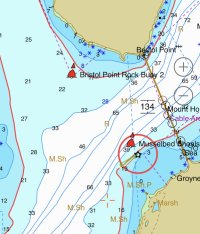
Narragansett Bay MH Bridge sm.jpeg
We just had this happen recently in a part of Narragansett Bay where we rarely go. Approaching the passage under Mount Hope Bridge from the west I knew there was supposed to be a red buoy to the right but couldn't see it on the water or our B&G chart plotter. I finally zoomed in a lot and found Musselbed Shoals. But no hint that it was in a layer before zooming. Oddly, Bristol Point Rock showed up on the chart first, several powers of magnification less. We currently only run the charts that came with the B&G. They got us through cruising this summer but I'm not crazy about them.

This screen shot is from my phone running Wärtsilä iSailor. I got it years ago when it was free and you bought the charts once. They've since switched to an annual chart subscription. I've only used it as a small portable map, not for any real navigation so I can't give a review one way or t'other.
 
Top