• Untitled Document

    Join us on November 22nd, 7pm EDT

    for the CBEC Virtual Meeting

    Adventures & Follies

    All EYO members and followers are welcome to join the fun and get to know the people you've met online!

    See the link below for login credentials and join us!

    November Meeting Info

    (dismiss this notice by hitting 'X', upper right)

2018 Rendezvous - Charts, Customs, other considerations?

bgary

Advanced Beginner
Blogs Author
Thinking ahead a bit...

For those of us who have not yet ventured into Canada;

-- what charts should I have?

-- are there current guides or other resources worth having?

-- recommended routes to Genoa Bay (or routes to avoid)?

-- what are the "easy" ways to enter and exit Canada?

-- are there other considerations (such as, any issues with having a bottle or two of scotch on the boat, coming or going)?

At this point my thinking is to enter Canada at Victoria, and re-enter the US at Friday harbor, but open to other ideas and any tips that will make the process easier.

Thanks!
Bruce
 
Last edited:

Loren Beach

O34 - Portland, OR
Senior Moderator
Blogs Author
Customs note

One small bit of bureaucracy for US boaters is the annual sticker we are required to buy if our vessel is over 30 feet. The cost has been (and is) $27.50, and can be purchased ahead of time, directly from a government web site. This cost is predicted to rise on January 1, and the increase is said to be steep, altho I have not yet discovered the exact amount.
Anyhow, I ordered one for our boat yesterday.

You can buy this at the point of Customs re-entry, but it will add one more step to what might already be a hectic day when you are lined with a multitude of impatient & sometimes obnoxious Bayliner's at the Customs Dock. :rolleyes:

So, that's one part where early action can save you a few bucks and a few minutes.

URL: https://dtops.cbp.dhs.gov/main/#
and choose the option for Private Vessel.

It took me a few minutes and the use of our visa card.

If you are pre-enrolled in a pre-vetted phone-in clearance procedure, you would benefit by already having this sticker, as I understand things.
 
Last edited:

toddster

Curator of Broken Parts
Blogs Author
Thanks Loren, I had no idea. One of the FAQ's on the site:
Q: "What if my vessel has a 29-foot hull but the rigging extends 31 feet?" (Hmm... sounds familiar...)
A: "Please contact the port of entry where you will be entering." (i.e. it's up to the whim of whoever is on duty at the moment.)
 

Frank Langer

1984 Ericson 30+, Nanaimo, BC
We can provide a bit more information as we get closer to those dates. However, do read up on Canadian customs requirements. They may not allow fresh food or meat, and there are limits on alcohol and cigarettes. And for sure don't bring any guns across the border or they'll send you home in a hurry!!
But for those coming for the first time, Victoria is a lovely city, and Sidney just up the coast a bit is also quaint and a great stopping place for groceries, liquor, dinner out, etc.
The route to Genoa Bay is fairly straight forward but you will need charts of the gulf islands. They are really similar to the San Juan islands, but I think with less current in most areas.
The gulf islands are beautiful and worth spending extra time cruising.
There is a very shallow shoal on entry to Genoa Bay, well marked, and clear on the charts, but use caution as you enter the bay.
The marina is very pleasant, but there is also good anchorage in the bay, though that makes it harder to visit during the rendezvous.
I hope this helps. Others familiar with Genoa Bay may also want to add comments.
Frank
 
Last edited:

bgary

Advanced Beginner
Blogs Author
US Customs "Small Vessel Reporting System"

-- the Small Vessel Reporting System (info and application process) can be found here:

https://svrs.cbp.dhs.gov/Default.aspx

-- one must have the DTOPs decal (Loren referred to above) in order to apply for SVRS:

https://dtops.cbp.dhs.gov/main/#

-- if you are in the "NEXUS" trusted-traveler program it streamlines the SVRS application process:

https://www.cbp.gov/travel/trusted-traveler-programs/nexus/how-apply

-- and, as with all government programs, it's not as simple as applying. Must first create a "login.gov" account

https://ttp.cbp.dhs.gov/getstarted


parking this info in case it is useful to others....

_/)_
Bruce
 

Teranodon

Member III
DTOPS fee going up

Reading this thread reminded me that I needed to order the 2018 DTOPS decal. Since I have an account, it was easy. But there was a note on the site: the fee is going up for orders after January 1. So don't put it off, everyone! And, as always, don't ask what you are actually paying for....

Getting up into Canada is tedious, even if you have a NEXUS card. They usually make you go into one of the designated ports of entry. And, most of the time, there is no one there. For going north to Genoa Bay, I recommend checking in at Tsehum Harbour. Much easier in/out than Canoe Cove. But we can discuss all that in more detail as the date approaches.
 
Last edited:

footrope

Contributing Partner
Blogs Author
Thanks for the tip on the Decal price!

The Nexus card for US boaters has been good for us (and for airline travel - trusted traveler program, TSA pre-check). Our second 5-year card will be expiring before too long and we will renew. Entering Canada the phone-in process at Sidney or Bedwell Harbor is a little simpler - less questions, but in the past we had to go ashore. Coming back into the US we could cross the border and call in underway or when we got to an anchorage. A few years ago, cell coverage was spotty in the San Juans, so it was sometimes tough to stay connected. Now, with improvements in cell coverage, maybe it's better. We also switched to T-Mobile earlier in the year. Free calls in Canada.

I have heard that with new surveillance cameras at some Canadian check-in points, US boaters might be able to loiter in front of the dock and call-in on your cell phone. I haven't confirmed that yet.
 

supersailor

Contributing Partner
We use the I-68. It's a big pain to go to Seattle from Port Angeles to get the NEXUS. We can get the I-68 locally. It is only good for a year but it is inexpensive and convenient. A phone call at the border clears us.
 

supersailor

Contributing Partner
Toddster,

Go with the LOA that your registration shows.

Thanks Loren. I'll order mine now instead of later.
 
Last edited:

bgary

Advanced Beginner
Blogs Author
It's a big pain to go to Seattle from Port Angeles to get the NEXUS.

I applied for the NEXUS program yesterday.

Part of the process is to be interviewed by (I'm told) both US and Canadian security organizations. I'll try to get an appointment in Blaine, easier than Seattle for me.

In the meantime, I'm advised that the NEXUS approval process takes "months", so... anyone thinking about doing this in time for the summer cruising season, start now.

Bruce
 

Teranodon

Member III
I applied for the NEXUS program yesterday.

Part of the process is to be interviewed by (I'm told) both US and Canadian security organizations. I'll try to get an appointment in Blaine....

Bruce

I found the interviews in Blaine to be quick and easy. They mostly want you there to get photos and fingerprints. As long as you're making the trip, I recommend swooping up to Richmond for some of the best dim sum this side of the Pacific.

As already mentioned, NEXUS gets you TSA Pre on all flights.

Another good thing to have is a BR number for every person on board.
 

bgary

Advanced Beginner
Blogs Author
^^^ good to hear!

My plan, at this point, is to get registered for SVRS as soon as I have my DTOPs decal. I think that gets me a BR (Boater Registration) number.

And since it is usually "just me" on the boat, I think that (NEXUS + SVRS) is about as good as its going to get in terms of pre-streamlining my crossings.


In the meantime, I've figured out what charts I think I want to have on the boat, and have not discovered any "chart books" that look like they are suitable for actually navigating, so I'll probably be ordering some CHS (print on demand) charts from Captain's in Ballard before too long. It appears the Canadian Shipping Act requires that paper charts ("suitable for navigating") be on board, so even though I have the Canada chart-set in my chartplotter, and on my iPad, I'll get the paper backups too.

*Really* looking forward to my first jaunt toward the Straits of Georgia...
 

Frank Langer

1984 Ericson 30+, Nanaimo, BC
If you are going to be cruising in the gulf Islands more frequently, you might want to buy the Gulf islands chart book. It's about 25 pages of detailed charts with additional info on anchorages, cautions, etc. It's about $90 Canadian, but worth the money for sailing in the gulf Islands.
There are other individual charts available as well, but the chart book is best.
Frank
 

Teranodon

Member III
My plan, at this point, is to get registered for SVRS as soon as I have my DTOPs decal.


I just remembered: you may not want SVRS! In fact, the local CBP officer talked me out of it when I asked him. I'm pretty sure that you have to file a "float plan" whenever you use it. Then you have to stick to the plan. As far as I understand, the best combo is NEXUS + BR number (and the latter is just for speeding the telephone interaction with CBP when you are returning to the US). To fully benefit from NEXUS, every person on board has to be a member. If anyone is non-NEXUS, you'll have to physically check in; otherwise you can just go to your marina.

I have a little incantation that I use when calling CPB/NEXUS (800 562 5943): "Good morning/afternoon. I'm requesting permission to return to the United States from Canada by boat. There are two persons on board, both U.S. citizens, both have BR numbers". I find this gets the interaction off on the right foot. I have all my info handy on a single piece of paper: NEXUS and passport numbers, dates/places of birth, boat registration number, DTOPS decal number, Canadian entry number.

And another thing: any infraction will get you booted out of NEXUS. Like not checking into Canada, or even trying to sneak into the U.S. with a slice of ham. That small NEXUS card is a monument to governmental stupidity: there are three numbers on the back. So which one is the "NEXUS number"??? You guessed it: it's not the one with the biggest font. In fact, it's the one labelled PASSID. Go figure.

And another: that Gulf Islands chart book is money well spent. There is also one for Desolation Sound. If you have a Garmin chartplotter, make sure it has chart data for Canada. The chip that comes with the unit peters out on the border. You can get a complete West Coast of NA chip on ebay (or from Garmin at 4 times the price).
 
Last edited:

bgary

Advanced Beginner
Blogs Author
the best combo is NEXUS + BR number

Thanks! I don't know anything about the BR number, except that you get one when you register for SVRS. Is there another/better way to get one? Worst case, I'll ask the CBP interviewer when I go up to Blaine.

Great tips on the interaction. I travel around the US with... uh... politically-incorrect competition gear (?) and I've found that if I tell the airline counter agent what I'm checking in, and give them all the information they need right up front, the interaction goes a lot more smoothly.

Thanks for the tips on the chart-guides, too. No plans (at this point) to hit the Gulf Islands in 2018 (except I'm thinking I might go around the north end of Saltspring on my way back from the rendezvous, just for grins/sightseeing), but I'll look for that Gulf Islands chart guide. If nothing else, it'll be a fun thing to peruse over the winter.

And, yeah, my Garmin has the US map-set, and I added the Canada map-set, so should be good to go there.

Bruce
 

bgary

Advanced Beginner
Blogs Author
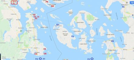
Parking this here in case it is useful to other cross-border newbies thinking about the 2018 rendezvous...


entry points.jpg

This is (I think) a survey of the various Canadian- and US-entry points relevant for a trip to Genoa Bay

Red letters (Canadian)
VH = Victoria Inner Harbor
OB = Oak Bay Marina
CB = Cadboro Bay
PS = Port Sidney Marina
TH = Tsehum Harbor
VI = Van Isle Marina
CC = Canoe Cove
Have also shown Port Browning (PB, Nexus only) and Bedwell Harbor (BH)

Blue letters (US)
RH = Roche Harbor
FH = Friday Harbor
BE = Bellingham (must call ahead)
AN = Anacortes
EV = Everett (must call ahead)
PT = Port Townsend (must all ahead)
PA = Port Angeles
 
Last edited:

bgary

Advanced Beginner
Blogs Author
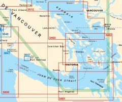
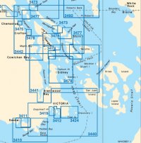
Parking these here, too. Snips of the Canadian Pacific-coast chart catalog (catalogue)

Can charts 01.jpg

Can charts 02.jpg

I figure (for me and my expected routing), at minimum I'll get
-- 3461 and 3462
-- 3440 and 3441
-- 3478, 3479 and maybe 3412 and/or 3424
(plus, of course, the relevant US charts for the area, primarily 18421 and 18465, and appropriate approach/detail charts for San Juans, Port Townsend, Anacortes, etc)

A PDF of the Canadian Pacific-coast chart catalog can be found here:

http://www.charts.gc.ca/documents/charts-cartes/pacific-index.pdf

A PDF of the Canadian aids-to-navigation doc can be found here:

http://www.inter.dfo-mpo.gc.ca/folios/00020/docs/CANS-Map-2011-eng.pdf

...and, a PDF of the Canadian "Chart 1" can be found here:

http://www.charts.gc.ca/publications/chart1-carte1/index-eng.asp


Happy planning!
Bruce
 
Last edited:

Frank Langer

1984 Ericson 30+, Nanaimo, BC
Bruce, in Canada those charts cost about $20 each, compared with a whole chart book of about 24 charts that costs about $88 and covers that whole area. The one for the Gulf Islands, which also includes some charts for the San Juan islands, is chart book 3313 in Canada, if I remember correctly and it's widely available. Just a thought...
Frank
 

bgary

Advanced Beginner
Blogs Author
chart book 3313 in Canada

Thanks!

The only chartbook I've seen (actually laid eyes on) for the area was one called the "Marine Atlas", and I was not impressed with it. It seemed like pretty poor reproductions of not-up-to-date charts.

I expect the CHS chartbook #3113 is of much better quality, and Paradise Cay (www.paracay.com) says they have one in stock. (ETA: ordered!)

On a related note, the local chandler has a number of cruising guides for the Gulf Islands / Southern Vancouver Island.... are any of these worth the money?

-- Dreamspeaker Cruising Guide: Gulf Islands and Vancouver Island (Yeadon-Jones)
-- Cruising the Gulf Islands (Vassilopoulos)
-- Exploring the South Coast of British Columbia, Gulf Islands (Douglass)
-- Cruising Guide to British Columbia, Gulf Islands (Wolferstam)

Of the ones I've seen, the Dreamspeaker seems to have the best mix of information, but... don't want to waste the money if there are other one(s) worth buying.

Bruce
 
Last edited:
Top