Simrad ST22 mated with GPS??

I think I've decided to go with the Simrad ST22 for our E29 based on all I've read here. However, I'm curious as to how you connect this to GPS to have the control from the GPS head unit. I have a waterproof Garmin Quest 2 that we can use, but don't know if it would be compatible or if I'll have to buy a different unit to get control of the tiller pilot.

Any thoughts or help on this?
 

Guy Stevens

Moderator
Moderator
NEMA Connections TP22

Directly from the manufactures Manual. Spelling errors are theirs, Page 22 by the way.:

If a GPS or chartplotter is connected to the Tillerpilot, it can
extract the data necessary for Nav mode. Other functions such
as Steer To Wind may also be available, if NMEA0183-compatible
instruments are transmitting the correct NMEA sentences.
When connecting an external (“talker”) unit to the Tillerpilot,
two terminals are used – usually labelled DATA and COMMON
(or COM). These should be connected to the Tillerpilot’s
NMEA cable as follows :

NMEA Out Data/+ --> Tillerpilot Data (Red)
NMEA Out Common/- --> Tillerpilot Common (Blue)

NOTE Some third party equipment does not have a dedicated
COMMON connection. In this case, the DATA connection will
usually be labelled NMEA OUT, and the NMEA Common wire
from the Tillerpilot should be connected directly to 0v (terminal
2). If in any doubt, refer to the manufacturer, or Simrad’s
Product Support department for advice.

Guy
:)
 
That sounded like Greek to me, I thought these were Nordic Vessels!!! ;) Anyone know of a specific, reasonably priced GPS unit that will work with the Simrad T22?

Thanks!
 

Rob Hessenius

Inactive Member
Greek

Bart-- That was'nt Greek at all! You asked a question and recieved a "GREAT" response. I don't want to sound as to be critical, but you wanted to know how to hook up a Simrad 22. By the way congrads to your purchase of the 29. Rob Hessenius
 
re-worded question

You are correct. After re-reading my post, it was a "Great" answer. I was actually looking for a recommendation for a reasonably priced GPS unit that I could buy that would work with the TP-22. I went back and researched and found that my Garmin Quest 2 does not have an NMEA 0183 output.
Thanks!
 

bigtyme805

Member III
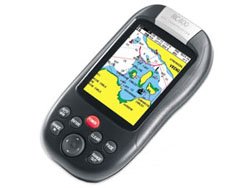
What is your budget for the GPS with the NMEA outputs? I have a Raymarine GPS/Chartplotter that I paid 399 for and interfaces with my Simrad TP-30 not my Simrad TP-10. It is a great portable GPS and has a 5in screen. I am sure you can find much cheaper. There is a brand called Lowrance that interfaces with NMEA and I believe they have the lowest prices on the market and are carried by Boaters World. I have no experience on how efficient they are. Good luck on finding one.

By the way when get the units and start interfacing you will find that they are very easy to hookup.
 

Rob Hessenius

Inactive Member
Gps

Bart- It will be hard to find a better deal out there than the Garmin Map 76 @ $200. Monochrome screen, 8mb of memory, built in base map, water-proof and it floats. This unit can be interfaced with your Simrad easily with the PC/Data cable. There is a color version Map 76CX, color screen, I think 128mb for $400. These units are handhelds and will last you for years to come, also great back-ups if or when you might up-grade to a larger fixed mount plotter. You can see both of these units at West in Hermitage and compare. Rob Hessenius
 
Last edited:

Loren Beach

O34 - Portland, OR
Senior Moderator
Blogs Author
Another handheld Waas GPS that you might want to keep your eye out for is the out-of-production Standard Horizon Magnum Nav-40.
I have owned one for several years and it works well. Quick to acquire, and the monochrome screen is very easy to read.

Only downside is that it uses up it's battery pack while "off." Some sort of power management flaw... After sitting on the shelf for 3 months they run down.
They do have a factory combination power supply and data cord that plugs in. Since it is waterproof one could mount it at the helm and presumably interface it with the AP.

I say presumably because I have used it only for offshore trips and deliveries to get lat and lon for backup charting. It is funny how every trip we go on nowadays finds every person on board with their own little GPS!
:rolleyes:
If we have it on continuously at the helm to watch our speed made good and progress, it will use up the internal batteries in about 9 hours, maybe a bit further.

For the original $149. it is a lot of technology for the b.u.c.

Loren
ps: just looked on eBay, found none of this model for sale... go figure.
 

Jeff Asbury

Principal Partner
I have the Simrad TP-22 interfaced with the Magellan Meridian Marine hand held GPS. I went with the TP-22 because it was rated for boats up to 32 feet. No such thing as over kill when it comes to auto pilots. It also came with a remote control that I never use. Nice feature that has 20 feet of cable so in theory I should be able to steer the boat from the bow, but why would I want to.

Interfacing was not that difficult after I read both the manuals for my GPS and Tiller Pilot. I did have to purchase the bare wires power connector for my Magellan separately so that I could hard wire it to the Tiller Pilot. The GPS has three different NMEA settings to chose from. I selected the one recommended by Simrad and it works flawlessly. As far as I can see, if you have any two devices that have NMEA capabilities, interfacing them should not be a problem.

I have got to say that after I installed my tiller pilot it has changed my sailing habits dramatically. I single hand my boat much more often now. I just make sure I am wearing a harness. I wish that remote was a wireless one, then if I ever fell over board I could have my boat sail back to pick me up. Hey, why haven't they invented that yet?:confused: :esad: :egrin:
 
Last edited:

Guy Stevens

Moderator
Moderator
Quest 2

The Quest 2 appears to be one of those GPS that have the NEMA part of the chip disabled for other (Road Map) functions. Couldn't get specs on the power/ speaker cable to know for sure, and my Garmin Rep just rolled his eyes when I asked.....

I would probably recommend a good cheap and reliable Garmin GPS 12XL (note it has to be the XL module to support being hooked to 12 volts for power). They are available for less than $50.00 if you are patient on E-bay. $70.00 if you are impatient and want Santa to bring you one.

The Nema on the XL is easy to wire, set up, and use.

Guy
:)
 
Wow, lot's of great info guys!! I was looking in the $400 range tops. I spent nearly $600 for the Quest 2. Go figure, the thing is waterproof but no Marine interface!! Of course I bought it before I even imagined that I'd buy a sailboat so my bad. I would like the unit to be mounted to the bulkhead or on a pedestal so I didnt' want to go handheld. The Raymarine Chartplotter sounded good too!!
 

Dave Hussey

Member III
I've been reading this informative thread intently, because I plan to install a Simrad TP20 (the precurser to the TP22) this spring, and wondered if it will interface to my Garmin Rino 120 hand held GPS, which I bought from my son when he upgraded. ( I always wind up with 'hand-me-ups')If any body has done this, I'd love to hear how it went together. Sorry, I didn't intend to hijack this thread.
 

Rob Hessenius

Inactive Member
Fixed Mount GPS

Bart- If your desires are to have a fixed unit, take a look at the Garmin 172C, You should be able to find it for $400. I'm a Garmin fan as you can tell. They have some pretty cool stuff on the way for 07'. I don't know the price points yet or the specifics. The Raymarine that I think Don is speaking of is the 435C. Not sure if you will have any electronic charts that will support you on Kentucky Lake. The Navman line is kinda interesting, you get alot for your $, but support issues are kind iffy. Do your homework before buying a chartplotter. There are alot of specific issues to just you that you have got to sort through. Rob Hessenius
 

bigtyme805

Member III
Rob is right about the chartplotter. Make sure they have the maps for where you sail, they are extra. It's a chip that fits into the back. Example(I sail in So Cal and the map I bought covers from Seattle to Hawaii and some of Mexico. They have tons of maps and I am sure they have one for that area. Although it helps to be safe before purchasing. The interface was easy. If it was me I would look into the dual GPS/Chartplotter. The prices are good and you might as well get the best out of your buck.

Happy shopping!

The Raymarine GPS/Chartplotter RC400 that I have is no longer available only through ebay and some marine stores that still have them. Supposedly they are coming out with a newer version but for the life of me I can't see how you can upgrade more than what they have for the price.
 

Attachments

  • raymarine.jpg
    raymarine.jpg
    25.5 KB · Views: 268
Top