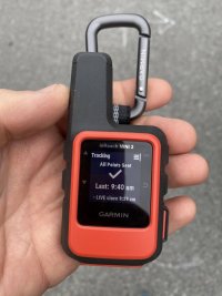
E32-200 Garmin InReach Mini 2 Set-Up

If I were invited to join a boat as crew for an offshore trip, after an iPhone, a Garmin Inreach Mini2 would be the next piece of personal safety and electronics that I would bring along.

Purchase Cost: $432 including CA sales tax, on Amazon.

Monthly Subscription: $15 to $65 per month, purchased directly via the Garmin web site.

I chose a midrange plan at $35 per month that can be canceled any time.

Recharge: USB-C cord.

Battery LIfe: Supposed to last 5-6 days if the unit is untouched, but use of the device for messages appears to shorten that timeframe.

I didn’t set out to write a positive glowing review of the inReach Mini 2. I wanted a “can attach to my lifejacket and forget about” satellite communicator, and the Mini2 is that, but with a lot more than I expected. It responds to many of the basic communications and navigation questions that an offshore sailor would want to know:

  1. Where am I?
The unit has a GPS tracker built in. Accuracy to within 3 feet, with a clear sky. .The easiest way I have found to obtain an instantaneous reading is to drop a waypoint, and then the Latitude/Longitude appear.

  1. Can I call for help if I need it?
There is an SOS button on the Mini2. When triggered, a message is sent to the Garmin International Emergency Response Coordination Center (IERCC) to request help. When activating a Mini2, the user inputs contact information and a brief “comment for emergency responders.”

This is not the same system that EPIRB and PLB’s use (Cospas-Sarsat), and one would probably want to have a fully-fledged EPIRB for a boat, but still. An SOS button with pre-set contact information from a company with a huge installed user base is fairly reassuring to me.

  1. Can my friends and family track my location passively?
Yes – there is a tracking feature that will have the Mini transmit its location automatically. There are similar dedicated tracking-only systems that cost nearly the same amount for the same ongoing costs or nearly.

This feature will not work if the unit does not have a clear view of the satellite sky.

emHQ4bChraYcuQMzlBt0LYN2htgdToxu9C3CWgxWMz5NO6U4uAL23vZCXuVcEWhTaN5WwWIgg19wsPCO1TMFJx6qGvhSd47vEswW0lv6KV2QMIVHHKoc_y2XBNWEo49oCakE9nNd

  1. Can I communicate with my friends and family in non-emergency situations?
Yes, there is an iPhone app (Garmin Explore) that allows one to send pretty text messages via the Mini. Emojis and all. This is probably the most likely to be used feature in my case (assuming I am not in a liferaft, SOS-ing).

Apps-bluetoothing-to-devices feels a little flakey for me as someone who grew up installing-drivers-for-devices in poorly-performing Windows PC environments. The thing is, modern bluetooth seems to work really well. Add the app to your phone, turn on your bluetooth and shazam, everything is there.

With an app connection in the iOS environment, developers have much greater capacity for user interface design, settings etc. than is afforded by the tiny low-battery-use LCD screen with several buttons that is integrated into the Mini unit itself. Sending texts (including three user-customized pre-set messages) is also possible without an iPhone and the app, but it is more laborious.

buks5Eqg4HsQA-t0o4MYcHhs12U2_52X_2PZKNJKLesMDumNxaYbX1QkENBFR0etQi0mrAC4BE7f6YYPECAmgiracr8Z2WsCxHsYui72rQC6ddOuIg8uv9Qe5McSuQTrMGsiH9LT

Compared to passive tracking this method provides the recipient of the tracking information with more data in that the sender must be well enough to type the message or press the button.

Once one has the device registered and activated, a Garmin website profile can be set up where messages sent to the device can also be read, and a unique URL link can be set for the device, such as: https://share.garmin.com/tomvilhauer

  1. Can I get weather information?
The Mini offers “basic” downloadable weather forecasts as part of the standard service. One can pay more for longer range predictions in a premium version.

xBLq1IJq7Kldd1TsJ5q14Fng30DUUI4FsTwiKw2tqNhZuYAjRCgddr-fb2fR5QB_0HlTdmJOSE0GhkHVOOH0z0WT42Z9N6UGQx6FQ-67zaL9stNC8b15moQrx499WxGa5qdXUtLI

There is also an option to get a Marine forecast for a dollar per download, showing a 7 day forecast with wind speed and direction, as well as wave height. One needs to be 5 miles offshore for this to work, and I haven’t yet had the opportunity to test it.

Disadvantages / Drawbacks

It’s not a "real" PLB/EPIRB and and it’s not totally waterproof. It’s supposed to be waterproof to an IPX7 standard, which means, google tells me, “waterproof when submerged in water at a depth of one meter, for 30 minutes.” So, don’t take it SCUBA diving.

Without the iPhone app, it’s a bit finicky for lack of buttons and with a small LCD screen.

All that said, for a tiny come-along satellite modem for my phone for texting etc? In all, it seems like good value.
  • IMG_5198.jpg
    IMG_5198.jpg
    96.8 KB · Views: 2,016

Blog entry information

Author
goldenstate
Views
678
Last update

More entries in Electronics - Navigation, Audio and Other

More entries from goldenstate

Top