First, get yourself a paper chart. I think it is the Cove Point to Smith Point chart. A GPS chart plotter would be nice if you where thinking about getting one.
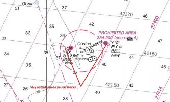
As for the trip itself that is pretty straightforward. After leaving Solomons cross the Patuxant to avoid the chop at its mouth and round Cedar Point. Next question is, do you want to be inshore or off shore of the Navy's target range. I would think this would depend on weather conditions, what mood the Navy is in and if you are sailing, or motoring. Next is Point No Point light and as you get near to it, resist following to close to shore from here all the way to Point Lookout. When Point Lookout is abeam you should find a green can. Make that can and then head for the Point Lookout light. You can cut inshore of the light, but be careful especially if the wind is up and blowing against the tide. It can get very choppy here and can be one of the most unpleasant places on the Bay in the right conditions.
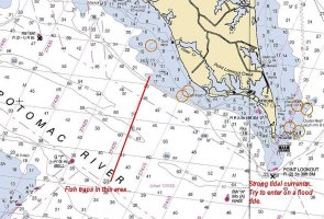
If you have had enough for the day you can go into Smith Creek or St. Mary's River. Both has nice anchorages. I would cross the Potomac in the river after St. Mary's, not at its mouth for a smoother ride.
I'd also make sure that you have confidence in your new boat. After you leave the Patuxant there is really no place to duck in until you are past Point No Point and that is St. Jerome Creek. After St. Jerome you have to make Point Lookout and Smith Creek. This can be a very long unconformable day if the weather and tide are not working together, so check the weather before you leave. Also, talk to the locals in Solomons with your chart in hand for the fine points, or as it is called "local knowledge".
Have fun.